Northeast States Geography Worksheet
Explore the geography and key features of the Northeast states with this engaging worksheet for Grade 4 students.
Includes
Standards
Topics
Northeast States Geography
Name:
Date:
Score:
Read each question carefully and answer to the best of your ability. Some questions may require you to look at a map of the Northeast states.
Refer to the map below to answer some of the questions.
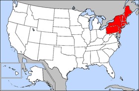
1. The Northeast region of the United States borders the Ocean.
2. The mountain range that runs through many Northeast states is the Mountains.
3. The largest state in the Northeast by land area is .
4. Which of these states is NOT considered part of the Northeast region?
Maine
New York
Florida
Pennsylvania
5. The capital of New York is New York City.
True
False
6. Name two major physical features found in the Northeast region.
Match each state with its capital city.
7. Massachusetts
a. Trenton
8. New Jersey
b. Boston
9. Pennsylvania
c. Harrisburg
Related Worksheets
Exploring the 50 States
A Grade 4 Social Studies worksheet to help students learn about the 50 states of the USA, including their capitals, abbreviations, and geographic locations.
Exploring Oceania
A Grade 4 social studies worksheet to introduce students to the geography, culture, and unique features of Oceania.
Capital Cities Challenge
A worksheet for Grade 4 social studies focusing on identifying and understanding capital cities around the world.
Physical Features of the Earth
Explore the different physical features of the Earth with this engaging worksheet for 4th graders.
Exploring Italy
A Grade 4 social studies worksheet to introduce students to the geography, culture, and famous landmarks of Italy.
Minerals and Rocks Worksheet
Explore the fascinating world of minerals and rocks with this Grade 4 worksheet, covering their properties, types, and uses.
States and Capitals Challenge
A worksheet for Grade 4 students to practice identifying US states and their capitals.
Understanding Political Maps
A worksheet for 4th graders to learn about political maps, including continents, countries, capitals, and boundaries.