Mapping Skills Worksheet: Grade 8
This worksheet assesses grade 8 students' understanding of mapping skills, including map elements, types of maps, and reading coordinates.
Includes
Standards
Topics
Mapping Skills Assessment
Name:
Date:
Score:
Read each question carefully and provide your best answer. For multiple-choice questions, circle the correct option. For short answer, write your response in the space provided.
1. Which of the following is NOT a main element of a map?
Scale
Compass Rose
Legend
Photograph
2. A map that shows elevation and landforms using contour lines is called a:
Political map
Thematic map
Topographic map
Road map
3. The imaginary lines running east and west around the Earth, parallel to the Equator, are called .
4. The is the ratio between a distance on a map and the corresponding distance on the ground.
5. Explain the difference between absolute location and relative location.
6. A physical map primarily shows boundaries of countries, states, and cities.
True
False
7. Refer to the world map below to answer the following questions:
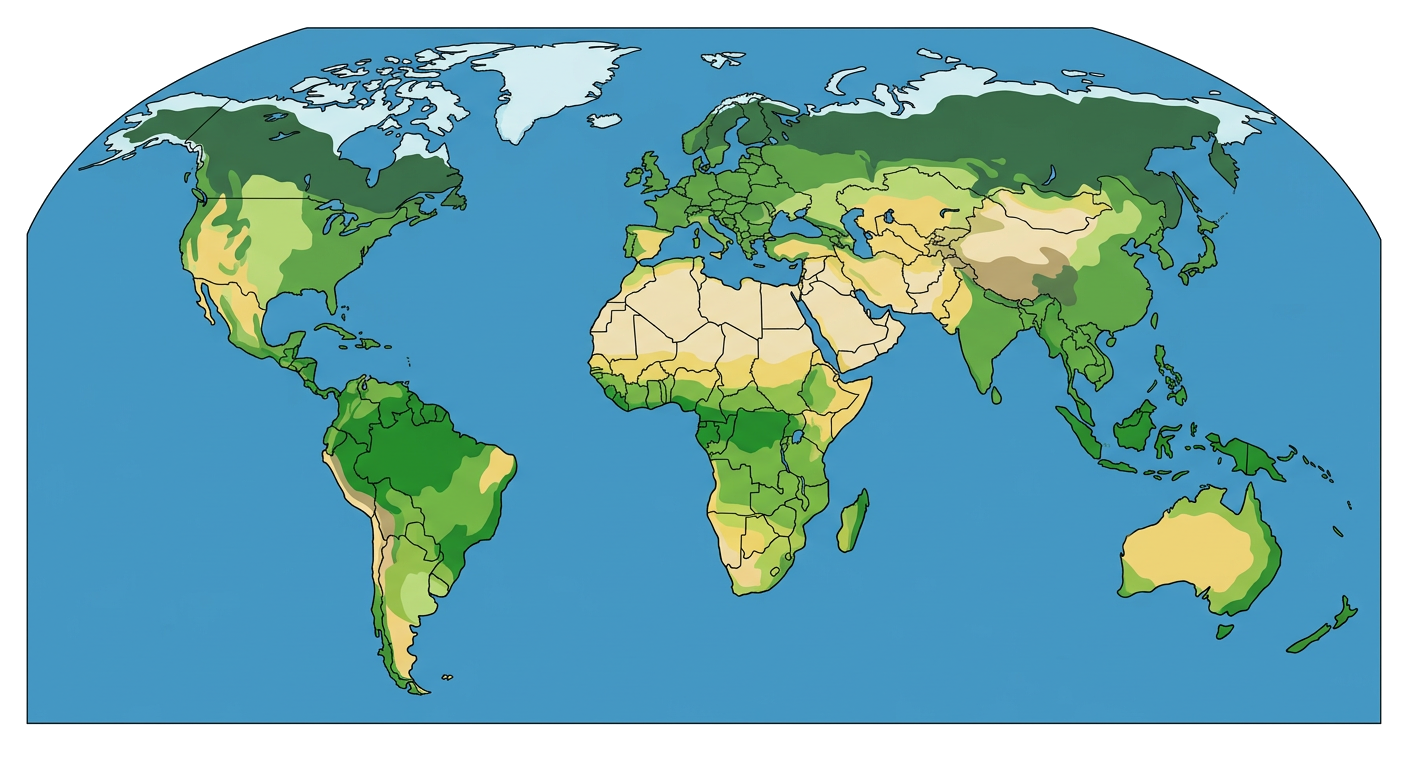
a. Name a continent that lies mostly in the tropical biome.
b. Which ocean borders the eastern coast of North America?
Related Worksheets
Population Pyramid Analysis
An 8th-grade social studies worksheet on population pyramids, their structure, and what they reveal about a population.
Countries of Asia Geography Worksheet
A Grade 8 social studies worksheet covering the geography, capitals, and key facts about countries in Asia.
Oceania Geography Worksheet
Explore the diverse geography and cultures of Oceania with this Grade 8 social studies worksheet, covering key regions, climate, and environmental challenges.
Regions of the United States Worksheet
Explore the diverse geographical and cultural regions of the United States with this engaging worksheet for 8th graders.
Geographical Boundaries Worksheet
Explore the concepts of different types of geographical boundaries, their formation, and their impact on human societies.
Climograph Analysis Worksheet
A Grade 8 social studies worksheet focusing on understanding and interpreting climographs to analyze climate patterns.
The Panama Canal: A Global Shortcut
Explore the history, construction, and impact of the Panama Canal with this comprehensive Grade 8 social studies worksheet.
Understanding Population Graphs
A worksheet for 8th-grade social studies students to understand and interpret population graphs, including population pyramids.