1763 Territorial Boundaries in North America
Explore the territorial changes in North America following the Treaty of Paris in 1763, focusing on British, French, and Spanish claims.
Includes
Standards
Topics
1763 Territorial Boundaries in North America
Name:
Date:
Score:
Read each question carefully and answer to the best of your ability. Refer to the map and your knowledge of the 1763 Treaty of Paris to complete the worksheet.
Refer to the map of North America in 1763 to answer the following questions.
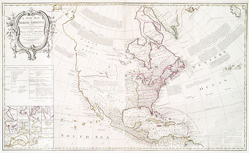
1. Which European power gained the most territory in North America as a result of the Treaty of Paris (1763)?
France
Spain
Great Britain
Portugal
2. The Proclamation Line of 1763 prohibited colonial settlement west of which geographical feature?
Mississippi River
Rocky Mountains
Appalachian Mountains
Great Lakes
1. The Treaty of Paris in 1763 officially ended the War.
2. As a result of the treaty, France ceded nearly all of its North American territory east of the Mississippi River to .
3. Spain gained control of from France prior to the Treaty of Paris, in exchange for Florida.
1. The British gained control of Florida from Spain after the Treaty of Paris.
True
False
2. The Proclamation Line of 1763 was established to prevent further conflict between colonists and Native Americans.
True
False
1. Describe one significant impact of the 1763 territorial changes on the relationship between Great Britain and its American colonies.